|
Sasniegumi pilsētu lietus ūdens apsaimniekošanā Baltijas jūras reģionā/Advancements in urban stormwater management in the Baltic Sea region
Klimata
pārmaiņu un pilsētu iedzīvotāju aizvien lielākās
koncentrēšanās radītajām problēmām nākotnē būs jāpievērš
aizien lielāka uzmanība un jāveic arvien nopietnāki pasākumi.
Tāpēc Baltijas jūras reģiona eksperti pēdējos trīs gados
pastiprināti un kopīgi ir izstrādājuši plānošanas atbalsta
risinājumu, lai mazinātu pilsētu teritoriju pluviālos plūdu
riskus. Šajā darbā aktīvi piedalījās arī Jūrmalas
vastspilsētas pārstāvji no SIA "Jūrmalas ūdens".
Plūdi, kas apdraud pilsētu
teritorijas un Baltijas jūru
Efektīva
pilsētas lietus ūdeņu pārvaldība ir viens no galvenajiem vides
risinājumiem nākotnē. Klimata pārmaiņu izraisīto ekstrēmo
laikapstākļu dēļ plūdi kļūst arvien biežāki, īpaši pilsētu
teritorijās. Tā kā pilsētu meliorācijas sistēmu jauda var būt
nepietiekama ekstremālo lietusgāžu situācijās, palielinās
risks, ka neattīrīti notekūdeņi var tikt neapzināti novadīti
vai noplūst dabā, tostarp Baltijas jūrā. Notekūdeņu noplūde ir
kaitīgas gan cilvēkiem, gan videi pārmērīgu barības vielu
aļģēm, bīstamo vielu un patogēno mikrobu daudzuma dēļ.
Atbalsta sistēma viedo
meliorācijas sistēmu plānošanai
Pilsētas
teritorijas var sagatavot pārmērīgam lietus ūdens daudzumam,
uzlabojot plānošanu un riska analīzi. Augstskolu, pētniecības
iestāžu, pašvaldību, ūdensapgādes uzņēmumu un asociāciju
partnerība no sešām Baltijas jūras valstīm ir strādājusi pie
plūdu riska mazināšanas BSR NOAH projektā 2019.-2021.gadā.
Projekta eksperti ir veikuši pasākumus un izstrādājuši jaunus
instrumentus pilsētas lietus ūdeņu apsaimniekošanai.
NOAH ir
izvēlētas astoņas izmēģinājuma jomas kontroles pasākumu,
uzraudzības rīku un plānošanas metožu testēšanai un ieviešanai
reālā pilsētvidē. Plūdu riska analīžu veikšanai ir izveidoti
teritoriju modeļi. Balstoties uz modelēšanā iegūtajām
zināšanām, ir izvēlētas piemērotas vietas monitoringa un
vadības ierīču uzstādīšanai, kas paaugstina meliorācijas
sistēmas efektivitāti. Turklāt, lai uzlabotu telpisko plānošanu,
ir izveidota jauna metodoloģija teritoriju plūdu risku izpētei –
gan pašreiz, gan nākotnē atbilstoši izvēlētiem klimata
scenārijiem. NOAH rīks Extreme Weather Layer (EWL) apvieno lietus
ūdens apsaimniekošanu ar telpisko plānošanu, lai sniegtu
informāciju par to, kā esošās iekārtas padarīt izturīgas pret
klimata pārmaiņu ietekmi.
Jūrmalas
pilsētā tika izveidota automātiskā hidroloģiskā stacija. Šī
ierīce no caurplūdes mērītājiem ievāc nozīmīgus datus par
plūsmas un dziļuma parametriem notekūdeņu sistēmā; līmeņa
parametrus lietus ūdens sistēmā no līmeņa sensora; nokrišņu
datus no vietējām meteoroloģiskām stacijām. Lietus ūdens
paraugi tika savākti, izmantojot automātisko paraugu ņemšanas
ierīci, un tika analizēti vairāki parametri, izmantojot mobilo
daudzparametru sensoru. Apkopotie dati liecina par zināmu korelāciju
starp nokrišņiem, ūdens līmeni lietus ūdens sistēmā un plūsmu
kanalizācijas sistēmā. NOAH projekta ietvaros Jūrmalā tika
izstrādāts Miera ielas rajona pilotposma modelis, kas dod iespēju
analizēt lietus ūdeņu riskus šajā teritorijā un tas ir
izmantojams tālākā pilsētplānošanas darbā.
Ieguvumi visam Baltijas
jūras reģionam
NOAH
projektā aprobēto darbību un instrumentu pielietošana var pat uz
pusi samazināt piesārņojošo vielu ieplūšanas no pilsētu
teritorijām Baltijas jūrā. Projekta darbības laikā izstrādātais
EWL plānošanas risinājums ir pārbaudīts un pielāgots
partnerpilsētu pilsētplānošanas procedūrai. NOAH koncepcija ir
viegli pielāgojama jebkurai pilsētas teritorijai ap Baltijas jūru.
Kā jau minēts, tad šī projekta mērķis ir klimatam draudzīgu
plānošanu iekļaut pilsētu un ūdensapgādes uzņēmumu ikdienas
praksē, mazināt klimata pārmaiņu ietekmi un starptautiskā mērogā
aizsargāt Baltijas jūru.
Interreg Baltijas jūras
reģiona NOAH projekts
● NOAH "Baltijas jūras
aizsardzība pret neattīrītu notekūdeņu noplūdēm plūdu laikā
pilsētu teritorijās",
● Finansē Interreg Baltijas
jūras reģiona programma
● 18
partneri no sešām valstīm Tallinas Tehnoloģiju universitātes
vadībā
● 2019. gada
1. janvāris – 2021. gada 31. decembris
● Projekta vietne:
sub.samk.fi/noah
● NOAH koncepcijas
rokasgrāmata: https://sub.samk.fi/noah_handbook_30112021/
Kontakti:
Projekta koordinators, Ivars
Annus
Tallinas
Tehnoloģiju universitāte, Igaunija
E-pasts: ivar.annus@taltech.ee
Projekta komunikācijas
vadītāja Hanna Rissanen
Satakuntas Lietišķo zinātņu
universitāte, Somija
E-pasts:
hanna.rissanen@samk.fi
Challenges
caused by climate change and urban densification will demand more
attention and measures in the future. Experts in the Baltic Sea
region have developed a planning support solution to mitigate
the pluvial flood risks of
urban areas.
Floods
posing
risks to urban areas and the Baltic Sea
Effective
management of urban stormwaters is one key factor among environmental
solutions in the future. Due to the weather extremes brought about
by climate change, floods are becoming more frequent, especially in
urban areas. As the capacity of urban drainage systems may
be
insufficient in extreme rainfall situations, the risk of untreated
wastewater being flushed into the nature, including the Baltic Sea,
increases. Wastewater spillages are harmful to people and the
environment due to the excessive amount of nutrients, hazardous
substances, and pathogenic microbes.
Support
system for planning smart drainage systems
Urban
areas can be prepared for the
excessive rainwater volumes
by improved planning and risk analysis. A partnership of
universities, research institutions, municipalities, water utilities
and associations from six countries around the Baltic Sea have worked
for flood risk mitigation in the BSR NOAH project in 2019-2021. The
experts in the project have taken measures and developed new tools
for urban stormwater management.
In NOAH,
eight pilot areas have been chosen for testing and implementing
control measures, monitoring tools and planning methods in real urban
environments. Models of the areas have been created for conducting
flood risk analyses. Based
on the knowledge gained by modeling, appropriate locations have been
chosen for the installation of monitoring and control devices which
enhance the drainage system's efficiency.
Furthermore, to enhance spatial planning, a new methodology for
investigating the areas’ flood risks – whether currently or in
the future according to selected climate scenarios – has been
created. The NOAH tool, Extreme Weather Layer (EWL), combines
stormwater management with spatial planning to provide information on
how to make the existing facilities resilient to the impacts of
climate change.
In the
city of Jurmala, automatic hidrologival station (hereafter, AHS) was
created. AHS gathers valuable data on the flow and depth parameters
in the sewage system from flow meters; level parameters in the storm
water system from the level sensor; precipitation data from local
meteostations. Storm water samples were collected using automatic
sampler and some parameters were analyzed using mobile multiparameter
sensor. Gathered data has shown some correlation between
precipitation, level in the storm water system and flow in the sewage
system. Within NOAH a model of the a pilot section of Miera street
district was developed, which gives the possibility to analyze
stormwater risks in the area and can be used for urban planning.
Benefits
for the entire Baltic Sea region
Implementation
of the NOAH actions and tools can cut up to half of the inflow of
pollutants from urban areas into the Baltic Sea. During the project
lifespan, the EWL planning solution has been tested and adapted to
the urban planning procedure of the partner cities. The NOAH concept
is easily scalable to any urban area around the Baltic Sea. The aim
is to the
climate-aware planning
into the daily practices of towns and water utilities, to
mitigate
impacts of climate change, and to
transnationally protect the Baltic Sea.
Interreg
Baltic Sea Region NOAH project
NOAH
"Protecting Baltic Sea from untreated wastewater spillages
during flood events in urban areas",
Funded
by the Interreg Baltic Sea Region Programme
18
partners from six countries, led by Tallinn University of Technology
1
January 2019 – 31 December 2021
Project
website: sub.samk.fi/noah
Handbook
of the NOAH concept: https://sub.samk.fi/noah_handbook_30112021/
Contacts:
Project
coordinator, Ivar Annus
Tallinn
University of Technology, Estonia
E-mail:
ivar.annus@taltech.ee
Project
communication manager, Hanna Rissanen
Satakunta
University of Applied Sciences, Finland
E-mail:
hanna.rissanen@samk.fi
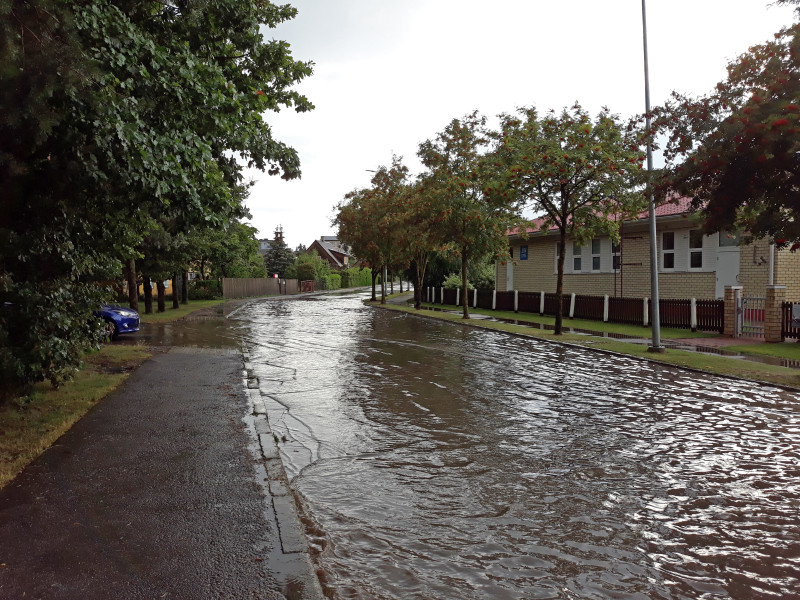
Plūdi
Hāpsalu, Igaunijā, vienā no NOAH projekta izmēģinājuma
teritorijām/Flood in
Haapsalu, Estonia, one of the NOAH project’s pilot areas. Photo:
Nils Kändler
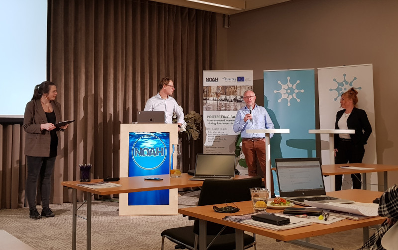 NOAH
eksperti Nils Kāndlers (Tallinas Tehnoloģiju universitāte), Pīters
Stēns Mikelsens (Dānijas Tehniskā universitāte) un Magdalena
Gajevska (Gdaņskas Tehnoloģiju universitāte) jautājumu un atbilžu
sesijā NOAH noslēguma seminārā 2021. gada 23. novembrī/NOAH
experts Nils Kändler (Tallinn University of Technology), Peter Steen
Mikkelsen (Technical University of Denmark) and
Magdalena Gajewska (Gdańsk University of Technology) at
the Q&A session in the NOAH final seminar on 23 November 2021.
Photo: Katrin Kaur
|